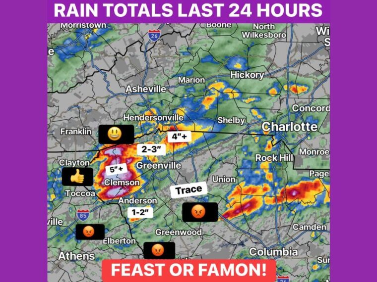
GREENVILLE, SC — Rainfall over the past 24 hours has been a true feast or famine across the Upstate and western Carolinas. Some areas near Clemson picked up more than 5 inches, while others nearby saw only a trace. The boundary responsible for Saturday’s storms stalled farther north than expected before pushing south overnight. A wedge boundary has now moved all the way toward Interstate 20, shifting the focus for additional rain much farther south today.
Heaviest Totals Top 5 Inches Near Clemson
The highest rainfall totals over the past 24 hours fell near Clemson and the area west of Greenville, where more than 5 inches was recorded. A second heavy pocket of 4 inches or more fell near the North Carolina and South Carolina border south of Hendersonville.
Between Clemson and Greenville, totals generally ranged from 2 to 3 inches. Anderson picked up 1 to 2 inches, while heavier rain also fell in pockets near Toccoa and Clayton.
Many Areas Saw Little to No Rain at All
Not far from the heaviest totals, other areas came up nearly dry. Only a trace of rain fell near Union and toward Greenwood, while areas near Elberton and Athens also saw very little.
Many residents changed plans because of the forecast rain, only to see little or none fall. The sharp difference in totals over short distances left some communities soaked and others still waiting for meaningful rain.
Rain Fell East of Charlotte Near Monroe and Camden
Heavier rain also developed east and southeast of Charlotte, including areas near Monroe, Pageland, and Camden. Some of these locations saw moderate to heavy totals during the past 24 hours.
Charlotte, Rock Hill, Shelby, and Hickory saw lighter and more scattered amounts. Areas farther north near Asheville, Marion, and Boone also picked up only spotty rain.
Wedge Boundary Brings a Chilly Morning and Shifts Rain South
Overnight, the boundary finally pushed south, bringing a chilly Sunday morning with temperatures in the upper 50s and lower 60s. The cooler wedge air has now spread across much of the region.
With the wedge boundary reaching toward Interstate 20, returning rain and storms later today will focus much farther south. Many areas will end up with considerably less rain than originally expected, and some may see very little additional rain at all.
Panthers Game Looks Better as Cool, Crisp Week Arrives
The forecast change brings good news for the Panthers game, with conditions looking much better for Sunday night. Drier weather is expected to take over as the rain focus moves south.
A beautiful, cool, and crisp October week is ahead for the region once the clouds clear out. Attention will then turn to another potential rainmaker next weekend, which forecasters will be watching closely.
Stay with bananatreenews.today for the latest weather updates and local forecast coverage.