HOUSTON, TX — A tropical or subtropical storm could form in the Gulf later this week, bringing a growing threat to the northern Gulf Coast by next weekend. The hybrid nature of the system means it is likely to be a large, messy rainmaker, with strong winds felt far from its center. Areas from southeast Texas to the Florida Panhandle should monitor the disturbance closely. If the system becomes a named storm, it would be called Isaias.
Hybrid Storm Could Develop in the Western Gulf Late This Week
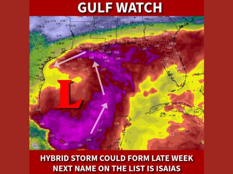
Low pressure is expected to take shape over the western Gulf later this week, with conditions favoring either tropical or subtropical development. A hybrid system often shares traits of both tropical storms and non-tropical lows.
That structure typically leads to a broader wind field and a larger rain shield than a compact tropical storm. As a result, impacts could reach well beyond the center of the system.
Deep Tropical Moisture Streams North Toward the Gulf Coast
Moisture levels across the central Gulf are running very high, with values near 2.5 to 2.7 inches over open water. Arrows on the forecast map show this moisture being pulled north toward the Louisiana coast and northwest toward southeast Texas.
Moisture values near 2.2 to 2.5 inches are already shown along the Louisiana and upper Texas coastline. That level of moisture supports heavy rainfall and the potential for flooding if the system moves closer to land.
Southeast Texas and Louisiana Face Rising Rain Threat
Coastal southeast Texas, including the Houston and Galveston area, sits near the western edge of the deepest moisture plume. Louisiana’s coast shows some of the highest moisture values near land, around 2.36 to 2.52 inches.
Heavy rain, gusty winds, and coastal flooding could affect these areas by next weekend. Low-lying coastal communities and areas with poor drainage would face the greatest flood risk.
Mississippi, Alabama, and Florida Panhandle Also in the Watch Zone
The threat extends east along the coastlines of Mississippi and Alabama into the Florida Panhandle. Moisture values near 2.1 to 2.2 inches are shown near the Panhandle and Big Bend region.
Because hybrid storms spread their impacts over a wide area, strong winds and heavy rain could reach coastal areas far from the storm’s center. Rough surf and higher tides are also possible along the northern Gulf Coast.
Northern Gulf Coast Residents Should Monitor Forecast Updates
Residents from southeast Texas to the Florida Panhandle should keep a close eye on forecast updates throughout the week. Details on the storm’s strength, track, and timing remain uncertain at this stage.
Now is a good time to review hurricane plans and check emergency supplies without panic. Forecasters will have a clearer picture as the disturbance begins to organize later this week.
Stay with bananatreenews.today for the latest weather updates and local forecast coverage.