KANSAS CITY, MO — An active winter storm pattern is expected across the central United States this season as key ocean and atmospheric patterns line up. A negative Pacific Decadal Oscillation combined with El Nino could fuel a very active winter across the country. Periodic shifts in the Eastern Pacific Oscillation may also open the door for colder air across the central and eastern states. The interaction between the polar and subtropical jet streams is expected to be one of the biggest drivers of winter storms this season.
Negative PDO and El Nino Point Toward an Active Winter
The Pacific Decadal Oscillation is expected to remain in a negative phase, at least early in the winter. It may trend toward a more neutral phase deeper into the season.
A negative PDO paired with El Nino can often lead to a very active winter pattern across the country. That combination is one of the main reasons forecasters expect multiple storm systems this season.
Positive EPO Could Bring Periods of Colder Air
At times this winter, the Eastern Pacific Oscillation could turn positive, which favors colder air across the central and eastern United States. When that happens, the polar jet can dip south into the Plains, allowing cold air to push farther south.
This pattern is not expected to be a constant feature through the entire winter. Instead, it is likely to happen periodically, especially as the season moves into its later months.
Polar Jet Dives Through the Plains as Subtropical Jet Crosses the South
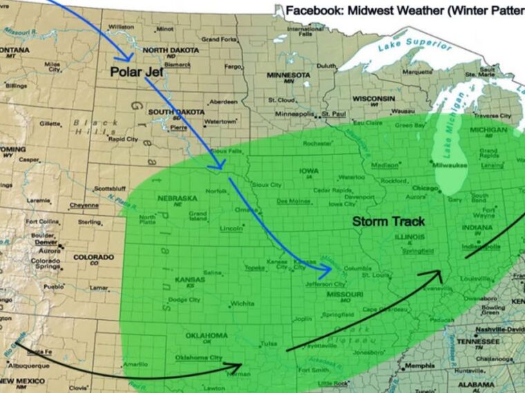
The winter pattern map shows the polar jet diving from Montana through the Dakotas, past Sioux Falls and Omaha, and into Kansas City and central Missouri. At the same time, the subtropical jet stretches from New Mexico across Oklahoma and Arkansas toward Indiana and Ohio.
Where these two jet streams meet and interact, storms can strengthen and produce significant winter weather. That interaction zone sits over the heart of the central United States.
Storm Track Covers the Central Plains, Midwest, and Ohio Valley
The highlighted storm track covers Nebraska, Kansas, northern Oklahoma, Iowa, Missouri, Illinois, Indiana, and southern parts of Minnesota, Wisconsin, and Michigan. It also extends into Ohio, Kentucky, northern Arkansas, and northern Tennessee.
Cities within this zone include Omaha, Des Moines, Kansas City, St. Louis, Chicago, Indianapolis, and Louisville. These areas could see multiple rounds of winter weather if the pattern develops as expected.
Analog Winters Show History of Major Storms
Analog years with similar large-scale patterns include the winters of 2015 to 2016 and 2019 to 2020. Both of those seasons featured multiple significant, large-scale winter storms.
The interaction between the polar and subtropical jets was one of the biggest reasons for that storm activity. Residents across the central United States should prepare for a potentially busy winter ahead.
Stay with bananatreenews.today for the latest weather updates and local forecast coverage.