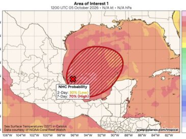
NEW ORLEANS, LA — Invest 92L is already showing signs of spin in the southwestern Gulf, with solid thunderstorm activity developing around it. A steady stream of moisture is expected to last through the week, adding fuel for a developing tropical system. Gulf waters are running slightly warmer than normal, and a large warm Loop eddy lies ahead in the system’s potential path. Hurricane development and even rapid intensification are now possibilities worth watching, though wind shear may limit strengthening near the coast.
System Begins Spinning Tuesday Morning in the Southwestern Gulf
Wind analysis from Tuesday morning showed Invest 92L beginning to develop a rotation in the southwestern Gulf near the Mexican coast. This early spin is a key first step toward tropical development.
Convection around the system remains solid, helping it organize. Continued thunderstorm activity near the center will be important for further strengthening over the next few days.
Deep Moisture Plume Supports Development Through Thursday
The European model, valid Thursday evening, shows a low near 998 millibars in the southwestern Gulf. A deep plume of moisture extends from the system north across the western Gulf toward the Louisiana and Mississippi coast.
Drier air is shown over the eastern Gulf, Florida, and parts of the Atlantic. The moisture stream feeding into the system is expected to last through the week, providing additional fuel.
Warm Loop Eddy Could Aid Strengthening
Gulf waters are running a little warmer than normal this week. A large warm Loop eddy sits across the central and eastern Gulf, holding deep, warm water beneath the surface.
These eddies have historically aided tropical development in the Gulf. If the system passes over this deep warm water, it could have extra energy available for strengthening.
Wind Shear May Weaken the System on Approach
Wind shear is expected to increase as the system moves north toward the Gulf Coast. Stronger shear could help weaken the storm before it approaches land.
The key question is how much shear will limit the system. Some higher-resolution hurricane models are showing the possibility of a stronger storm, which is considered historically believable given current conditions.
Northward Turn Likely as High Pressure Builds in the East
A turn to the north is very likely as high pressure builds over the eastern United States. That high pressure will act as a block, steering the system toward the northern Gulf Coast.
The exact timing and location of that turn remain uncertain. Residents from Texas to the Florida Panhandle should closely monitor updates over the next couple of days.
Stay with bananatreenews.today for the latest weather updates and local forecast coverage.