DES MOINES, IA — A strong cold front is expected to sweep through the central United States later next week behind a powerful, dynamic trough. Operational model guidance shows support for widespread frost and some freezes as the front moves east. A much cooler air mass will settle in once the front passes. Some severe weather is also possible just ahead of the front, though plenty of uncertainty remains.
Cold Front Stretches From the Upper Midwest to North Texas
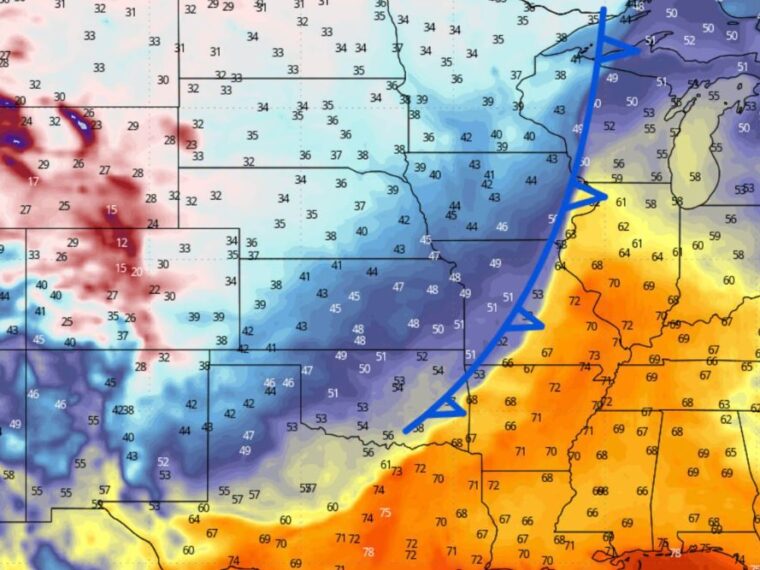
The projected position of the front stretches from Upper Michigan and Wisconsin south through Illinois and Missouri. It continues southwest into Oklahoma and north Texas as it pushes east.
Behind the front, much colder air spreads across the Plains and Upper Midwest. Ahead of it, warm air remains in place across the Ohio Valley, Tennessee Valley, and Southeast.
Temperatures Fall Into the 30s Across the Northern Plains
Temperatures behind the front drop into the 30s across Minnesota, the Dakotas, and Nebraska. Readings in the low to mid-30s are shown across much of this region, supporting widespread frost.
Iowa is shown with temperatures in the upper 30s to 40s, with colder readings possible in western and northern parts of the state. Kansas sees readings mainly in the 40s as the colder air arrives.
Rockies and High Plains See Freezing Temperatures
The coldest air on the map sits over the Rockies and High Plains. Temperatures in the 20s are shown across parts of Colorado and Wyoming, with teens in higher terrain.
Some areas in western Kansas, western Nebraska, and eastern Colorado also dip below freezing. These temperatures could bring the first hard freeze of the season for some locations.
Warm Air Holds East of the Front With Storm Potential
East of the front, temperatures remain in the 60s and 70s across Illinois, Indiana, Kentucky, Tennessee, and Ohio. Warmer readings in the 70s extend south toward the Gulf Coast.
The sharp contrast between warm air ahead of the front and cold air behind it could fuel some severe weather. Storms are possible just ahead of the front, though details on timing and strength remain uncertain.
Frost Timing Is Not Unusual for Many Areas
For some areas, these frosts are arriving later than average. Even so, the timing should not come as a surprise as the season moves deeper into October.
Residents across the Plains and Upper Midwest should prepare to protect sensitive plants and gardens. Keep checking forecast updates as the front’s timing and strength become clearer next week.
Stay with bananatreenews.today for the latest weather updates and local forecast coverage.