CHICAGO, IL — Thursday will be cooler than Wednesday across the Chicago area, with highs in the upper 60s to low 70s. Attention then turns to a fairly strong warm front lifting into the region Friday afternoon. Forecast data shows showers and thunderstorms developing and moving through the area along a broad zone of warm air advection. The chance for severe weather is very low, around 5 percent, but not zero.
Cooler Thursday With Highs in the Upper 60s to Low 70s
Thursday will bring a noticeable cooldown compared with Wednesday. Highs are expected to reach the upper 60s to low 70s across the Chicago metro and surrounding areas.
The cooler air will be short-lived as the warm front approaches Friday. Thursday should remain mostly quiet before the pattern becomes more active.
Storms Develop Along the Warm Front Friday Afternoon
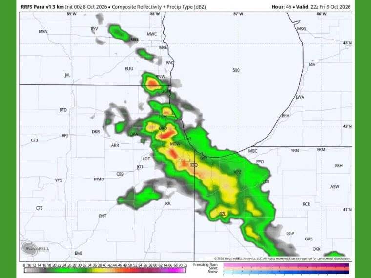
A high-resolution model valid around 5 PM Friday shows a band of showers and storms stretching from near Kenosha south through Waukegan and the Chicago metro. The band continues southeast across Gary and into northwest Indiana toward Valparaiso and Rensselaer.
Some of the stronger cores in the projection are shown near O’Hare, Midway, and Kenosha. Additional storms are shown near Joliet, Kankakee, Michigan City, and La Porte.
Strong Shear Could Support a Few Stronger Cores
Instability is not expected to be impressive Friday afternoon. However, fairly strong wind shear of 30 to 40 knots could allow a few storms to develop stronger cores.
Large hail is the main concern with any stronger storms. Damaging winds are less likely but cannot be completely ruled out.
Similar Warm Front Caused Damage Last September
A similar warm front moved through the region in late September last year and caused wind damage in a few spots. That event serves as a reminder that low-end setups can still produce surprises.
Because of that, forecasters will continue watching Friday’s setup closely. Any changes in instability could raise or lower the severe weather threat.
Severe Chance Very Low but Worth Monitoring
The overall chance for severe weather Friday remains very low, near 5 percent. Most areas are expected to see ordinary showers and thunderstorms.
Residents with Friday afternoon or evening plans should keep an eye on the forecast. Updates will follow if the setup looks more concerning later Thursday or Thursday evening.
Stay with bananatreenews.today for the latest weather updates and local forecast coverage.