DALLAS, TX — A band of showers and storms is expected to set up across North Texas early Friday, with rainfall totals of 1 to 4 inches possible where it develops. Rain is expected to begin around 1 AM and linger into the afternoon. The best chances are along and east of Interstate 35, though the exact placement of the heaviest band remains uncertain. Any rain will be welcomed as the region deals with ongoing drought.
HRRR Places the Heaviest Band Directly Over the Metroplex
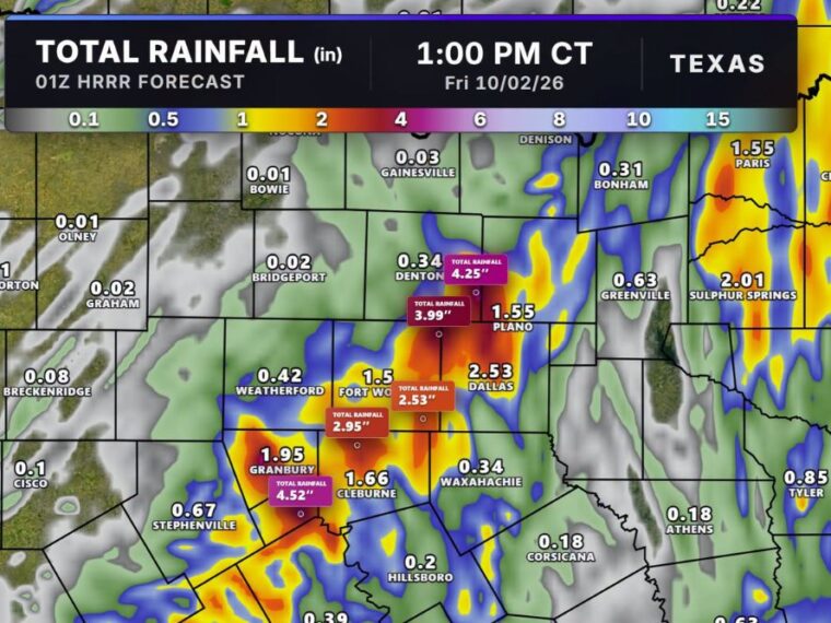
The latest 01Z HRRR run, valid through 1 PM Friday, shows a heavy rain band setting up directly over the Dallas and Fort Worth metroplex. Dallas is forecast to pick up 2.53 inches, with another 2.53-inch bullseye between Fort Worth and Dallas.
Fort Worth comes in at 1.5 inches, while a heavier pocket south of the city shows 2.95 inches. Plano is forecast at 1.55 inches as the band stretches north toward Denton.
Highest Totals Reach Above 4 Inches Near Denton and Granbury
The highest amounts on the model run reach 4.52 inches southeast of Granbury and 4.25 inches near Denton. A 3.99-inch total is also shown between Denton and Plano along the northern edge of the band.
Denton itself shows only 0.34 inches, highlighting how sharply totals could change over short distances. Granbury is forecast at 1.95 inches and Cleburne at 1.66 inches on the southwest side of the metroplex.
Totals Drop Off Quickly West and South of the Band
Areas west of the metroplex see much lighter amounts, with Weatherford at 0.42 inches and Stephenville at 0.67 inches. Bridgeport, Bowie, Graham, and Olney show only a few hundredths of an inch.
South of Dallas, Waxahachie comes in at 0.34 inches, Hillsboro at 0.2 inches, and Corsicana at 0.18 inches. Gainesville to the north shows just 0.03 inches, leaving much of the outer region with little relief.
Northeast Texas Sees Another Pocket of Heavier Rain
Farther northeast, Sulphur Springs is forecast to pick up 2.01 inches and Paris 1.55 inches. Greenville shows 0.63 inches, while Bonham comes in at 0.31 inches.
Tyler is forecast at 0.85 inches and Athens at 0.18 inches in East Texas. These totals depend heavily on where individual bands of storms set up through Friday morning.
Exact Placement of the Heavy Band Remains Uncertain
Models have consistently shown good rainfall potential for the metroplex, but pinpointing where the heaviest band will form remains difficult. A small shift could move the highest totals east or west of current projections.
Morning commuters across Dallas, Fort Worth, and surrounding cities should prepare for heavy rain, ponding on roads, and slower travel Friday. Residents should keep checking forecast updates as the band develops overnight.
Stay with bananatreenews.today for the latest weather updates and local forecast coverage.