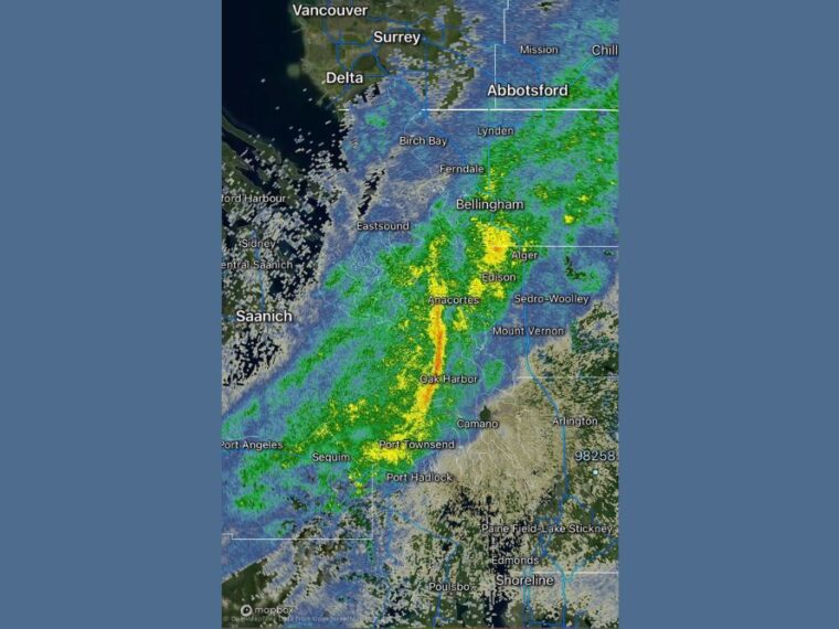
OAK HARBOR, WA — Heavier rain developed early Friday morning at the leading edge of strong westerly winds pushing down the Strait of Juan de Fuca. The heavy rain segment is expected to be brief as it moves east. Behind it, wind gusts of 40 to 45 mph are possible across Whidbey Island and Camano Island. A small chance of a 50 mph gust is also possible in the most exposed areas.
Heavy Rain Band Moves Across Whidbey Island
As of 6:21 AM Friday, radar showed a narrow band of heavy rain stretching through Oak Harbor and toward Anacortes. Heavier rain was also falling near Port Townsend and Sequim on the Olympic Peninsula.
This band marks the leading edge of the westerly winds coming in from the Strait of Juan de Fuca. The heaviest rain is expected to last only a short time as the band shifts east.
Skagit and Whatcom Counties Also See Heavier Rain
Additional areas of heavier rain were showing up near Bellingham, Alger, and Edison. Rain also extended toward Mount Vernon and Sedro-Woolley in Skagit County.
Farther north, lighter rain covered areas near Ferndale, Lynden, and Birch Bay. Rain was also spreading across parts of the San Juan Islands and southern British Columbia.
Gusts of 40 to 45 MPH Expected After the Rain
Once the heavier rain passes, wind gusts of 40 to 45 mph are possible across Whidbey Island and Camano Island Friday morning. Areas exposed to the open water are most likely to see the strongest gusts.
A small chance of a 50 mph gust cannot be ruled out. Winds of this strength can bring down tree limbs and cause scattered power outages.
Tulalip Reservation and Mission Beach Could See Similar Winds
Waterfront areas on the Tulalip Reservation, including Mission Beach, could see winds similar to those on Whidbey and Camano Islands. Locations near the shoreline face the greatest exposure to strong westerly winds.
Areas farther south, including Edmonds, Shoreline, and the Paine Field area, were mostly dry on radar at the time. Winds may be less intense away from the water.
Residents Should Secure Loose Items and Watch for Outages
Residents across Whidbey Island, Camano Island, and nearby coastal areas should secure loose outdoor items. Drivers on bridges and exposed roads should be prepared for sudden crosswinds.
Ferry travelers may also want to check for delays or rough conditions on the water. Conditions should gradually improve as the strongest winds move east later in the morning.
Stay with bananatreenews.today for the latest weather updates and local forecast coverage.