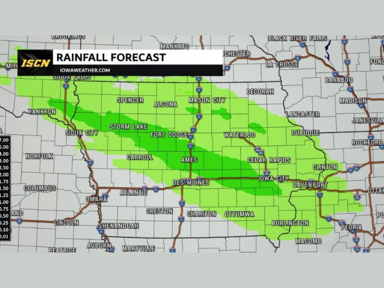
DES MOINES, IA — A new weather system arrives across Iowa later Thursday and Thursday night, bringing scattered showers and a few thunderstorms. Activity could first develop across northwestern Iowa during the afternoon before spreading south and east overnight. The greatest coverage is expected across central Iowa overnight into Friday morning, with some showers and storms reaching eastern Iowa. Most locations that see rain will pick up between a tenth and a quarter inch.
First Showers Develop in Northwest Iowa Thursday Afternoon
The first showers and storms could develop across northwestern Iowa Thursday afternoon. Areas near Sioux City, Spencer, and Storm Lake may see the earliest activity.
Additional showers and thunderstorms are expected to develop farther south and east Thursday night. Coverage will gradually expand as the system moves across the state.
Central Iowa Sees the Greatest Coverage Overnight
The heaviest and most widespread rain is expected across central Iowa overnight into Friday morning. A band of rainfall totals between a tenth and a quarter inch stretches from Storm Lake and Fort Dodge through Ames.
That band continues east through Waterloo, Cedar Rapids, and Iowa City toward Clinton and Davenport. These areas have the best chance of seeing measurable rain from this system.
Lighter Totals Expected Across Northern and Southern Iowa
Lighter amounts, generally under a tenth of an inch, are expected near Sioux City, Spencer, Algona, and Mason City. Des Moines, Carroll, Atlantic, and Ottumwa also fall in the lighter rainfall range.
Far southwest Iowa near Creston and Shenandoah may see little or no rain. Northeast Iowa near Decorah and Dubuque is also expected to see lighter totals.
Isolated Higher Amounts Possible With Repeated Storms
While most areas will see modest totals, some locations could receive less than forecast. Isolated spots could see higher amounts if thunderstorms repeatedly move over the same area.
These higher totals are expected to be localized rather than widespread. Brief heavy downpours are possible with any thunderstorms that develop overnight.
Rain Moves Out Friday Morning With Lingering Eastern Showers
The rain is expected to gradually move out of Iowa Friday morning. Most of the state should dry out by midday.
A few showers could linger into Friday afternoon across far eastern Iowa, including areas near Davenport, Clinton, and Burlington. Drier conditions are expected statewide by Friday evening.
Stay with bananatreenews.today for the latest weather updates and local forecast coverage.