DENVER, CO — Fall leaves are changing, but summer-like warmth continues across Colorado and the surrounding region Wednesday. Most areas will see plenty of sunshine and highs well above average for early October. The mountains have the best chance of a few afternoon showers and isolated thunderstorms. Warm weather holds through Saturday before a storm system could bring cooler temperatures, rain, and mountain snow Sunday into early next week.
Front Range and I-25 Reach the 80s Again
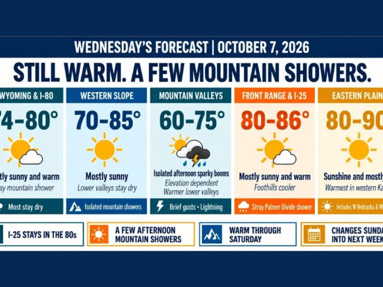
The Front Range and Interstate 25 corridor will be mostly sunny Wednesday with highs from 80 to 86 degrees. The foothills will run a bit cooler than the urban corridor.
Most of the I-25 corridor stays dry, though a stray shower could sneak toward the Palmer Divide. Morning layers will likely come off quickly as temperatures climb by midday.
Mountain Valleys See Afternoon Showers and Isolated Storms
Colorado’s mountain valleys will see highs generally from 60 to 75 degrees, depending on elevation. Lower valleys will be on the warmer end of that range.
Afternoon clouds will bring a few showers and isolated thunderstorms over the mountains. Brief gusty winds and lightning are possible where storms develop, so hikers should plan to be off high terrain by early afternoon.
Western Slope and Southeast Wyoming Stay Mostly Dry
The Western Slope will be mostly sunny with highs from 70 to 85 degrees. Lower valleys will stay dry and warmest, while a few showers favor the surrounding mountains.
Southeast Wyoming and the Interstate 80 corridor will see highs from 74 to 80 degrees with plenty of sunshine. A stray mountain shower is possible, but most locations stay dry.
Eastern Plains Warmest With Highs Up to 90
The eastern Colorado plains, western Nebraska, and western Kansas will see sunshine and mostly dry weather. Highs will range from 80 to 90 degrees across the region.
The warmest readings are expected in western Kansas. Rain chances remain very low across the plains through the afternoon and evening.
Cooler Changes Arrive Sunday Into Early Next Week
Thursday through Saturday will stay unusually warm, with only limited mountain shower chances. A storm system dropping into the western United States could then bring cooler temperatures, rain, and mountain snow Sunday into early next week.
The storm’s track and speed remain uncertain. A faster system would bring cooler air sooner, while a slower system could delay the cooldown and shift where the best moisture ends up, so specific rain and snow amounts are not yet clear.
Stay with bananatreenews.today for the latest weather updates and local forecast coverage.