RALEIGH, NC — Monday is starting with areas of fog and drizzle across North Carolina, along with some showers near the coast. Clearing will gradually increase from west to east through the day, with more sunshine the farther west you are. Highs will reach the 70s for most areas, running a little warmer in the western Piedmont. A cold front moving through tonight will push lingering rain offshore and bring cooler, crisp, less humid air for Tuesday.
Morning Fog, Drizzle, and Coastal Showers Start the Week
Fog and drizzle are spread across much of the state Monday morning, creating damp conditions for the commute. Showers are focused mainly along the coast during the early part of the day.
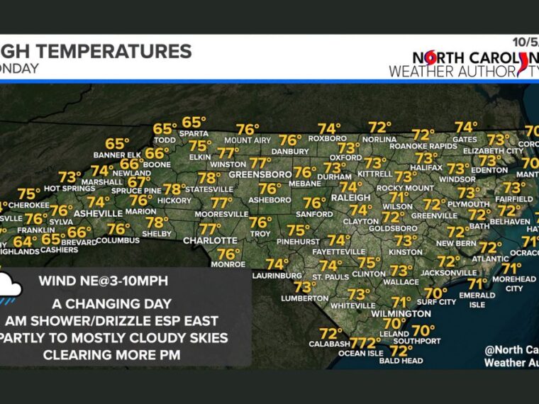
Skies will be partly to mostly cloudy early, with a northeast wind of 3 to 10 mph. Drivers should use caution in areas of fog, especially during the morning hours.
Clearing Moves From West to East Through the Afternoon
Sunshine will increase from west to east as the day goes on. Western North Carolina and the Piedmont will see the most sunshine, while eastern areas stay cloudier longer.
The coast may hold onto clouds and a few showers into the afternoon. By evening, clearing is expected to expand across more of the state.
Piedmont and Foothills Reach the Upper 70s
Some of the warmest highs Monday are in the western Piedmont and foothills, with Statesville and Shelby near 78 degrees. Charlotte is expected near 77, while Hickory, Mount Airy, Mooresville, and Monroe reach the mid to upper 70s.
Greensboro and Winston-Salem are also in the mid to upper 70s. Raleigh, Durham, and Fayetteville reach the low to mid-70s, while Sanford and Pinehurst are near 75 to 76.
Mountains Stay Cooler While the Coast Holds in the Low 70s
Higher elevations remain cooler, with Banner Elk, Sparta, and Cashiers near 65 and Boone near 66. Highlands is one of the coolest spots at 64 degrees, while Murphy and Franklin reach the mid to upper 70s.
Along the coast, highs stay mostly in the low 70s, with Wilmington, Corolla, Manteo, and Hatteras near 70. Greenville, Jacksonville, and Morehead City reach the low 70s.
Cold Front Brings Crisp, Less Humid Air for Tuesday
A cold front will move through North Carolina tonight, pushing any remaining rain in the east out to sea. Drier air will follow behind the front, lowering humidity across the state.
Tuesday is expected to bring cooler, crisp fall air with more comfortable conditions. The change will set up a pleasant stretch of weather heading into midweek.
Stay with bananatreenews.today for the latest weather updates and local forecast coverage.