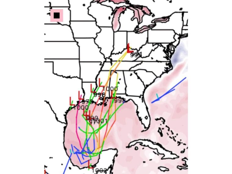
NEW ORLEANS, LA — Google DeepMind’s weather model is showing a range of possible tracks for a system developing out of the Bay of Campeche heading into next weekend. The track lines spread north across the Gulf toward Texas, Louisiana, Mississippi, and Alabama. These lines represent possibilities rather than confirmed landfalls, and the details are expected to shift. Gulf Coast residents are being urged to watch the trend without fixating on any single track.
Model Tracks Begin in the Bay of Campeche and Turn North
Most of the plotted tracks begin in the Bay of Campeche in the southwestern Gulf, with several lines looping and wandering before heading north. That clustering near the Mexican coast shows where the guidance agrees a system could first organize.
From there, the tracks fan out across the western and central Gulf. Some lines curve toward the upper Texas coast, while others push toward Louisiana and the Mississippi and Alabama coastline.
Possible Landfall Points Range From Texas to the Alabama Coast
Low pressure markers on the map appear along the upper Texas coast, across Louisiana, and near the Mississippi and Alabama coast. Projected pressures at those points range from about 975 to 1000 millibars.
The lowest reading on the model run, near 975 millibars, appears near the Texas and Louisiana border region. Other tracks show weaker systems, with pressures closer to 998 to 1000 millibars at the coast.
One Track Carries the System Inland Toward the Ohio Valley
At least one track pulls the system well inland after reaching the Gulf Coast, carrying it northeast across the Southeast. That line ends near the Kentucky and Ohio region with a pressure near 994 millibars.
Several other tracks also move inland across Mississippi and Alabama before fading. This spread shows the wide range of outcomes the model is still considering for next weekend.
DeepMind Model Performed Well on Hurricane Forecasts Last Year
Google DeepMind’s model was a top performer for hurricane track and intensity forecasts last year. That track record is one reason forecasters are paying close attention to what it is showing now.
Even so, a strong past performance does not lock in this forecast. Track guidance this far out often changes significantly as a system forms and new data is added.
Gulf Coast Residents Should Watch Trends and Avoid Panic
Residents from Texas through Alabama should keep an eye on forecast updates over the coming days. The tracks shown are possibilities, not confirmed landfalls, and should not be used to predict impacts at any one location.
There is no need to rush out for supplies based on this early model guidance. Normal hurricane season preparedness remains the best approach while forecasters monitor how the signal evolves.
Stay with bananatreenews.today for the latest weather updates and local forecast coverage.