RALEIGH, NC — A cold front moving into North Carolina will bring scattered showers and possibly a thunderstorm on Saturday. Rain is not expected to last all day anywhere in the state, with the morning and afternoon looking driest statewide. Shower coverage is expected to increase late Saturday afternoon into the evening and overnight hours. The severe weather threat remains very low to zero across the entire state.
Morning and Afternoon Look Driest With Only Isolated Showers
Saturday morning and early afternoon are shaping up to be the driest part of the day across North Carolina. Only isolated showers are expected during this window, giving many outdoor plans a decent start.
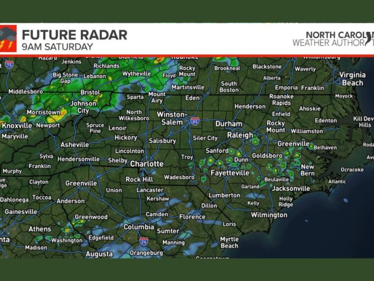
Future radar for 9 AM Saturday shows a few showers in the northwest near Mount Airy and Sparta. Light, scattered showers are also shown near Sanford, Dunn, Fayetteville, Goldsboro, and Greenville in the eastern part of the state.
Showers Become More Numerous Late Saturday Into the Overnight
As the cold front moves through, shower activity is expected to pick up during the late afternoon and evening. Scattered to numerous showers are possible from the evening into the overnight hours Saturday.
Later radar frames show showers spreading across the Piedmont, including areas around Charlotte, Winston-Salem, Durham, and Raleigh. Rain is also shown expanding toward Fayetteville, Lumberton, and the southern coastal plain later in the day.
NC State and Carolina Game Day Forecasts Look Mostly Manageable
NC State plays at 3:30 PM, and tailgating conditions look mostly dry at this point. Showers are possible at times during the game as rain chances increase later in the afternoon.
Carolina plays at noon, and tailgating looks pretty good ahead of kickoff. Shower chances are expected to increase as the game goes on, so fans should be ready for a passing shower.
Model Differences Leave Some Uncertainty in Rain Coverage
The future radar model appears to be handling the incoming weather pattern well, but it should not be taken literally. It offers a general idea of timing and coverage rather than an exact forecast for any specific location.
Other models show a much wetter outcome, though many of those are AI-based weather models. Forecast details could shift as more data comes in, with updated thoughts expected on Friday.
Outdoor Plans Should Include a Backup for Late-Day Rain
Anyone with outdoor plans Saturday, especially later in the day, should be prepared for rain at times. Some areas may see showers last longer than others as the front moves through.
Bringing a rain jacket or umbrella is a good idea for games, festivals, and evening events. With severe weather not expected, the main concern is passing showers and wet conditions rather than dangerous storms.
Stay with bananatreenews.today for the latest weather updates and local forecast coverage.