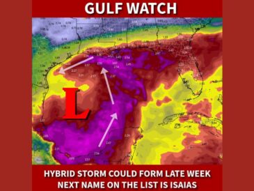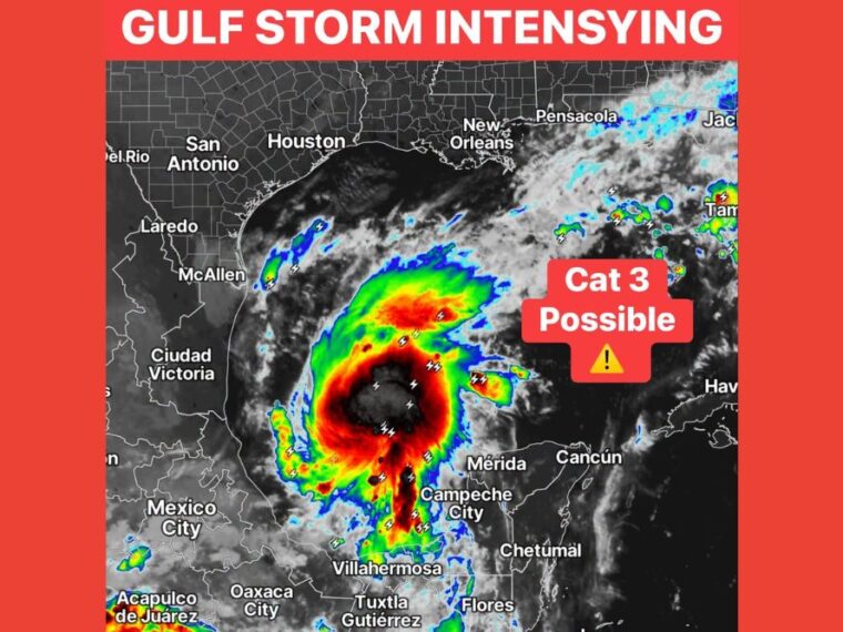
NEW ORLEANS, LA — Satellite imagery shows the tropical system in the southwestern Gulf organizing quickly. Overnight model runs have pushed the storm closer to Category 3 strength as it approaches the southeastern United States. A major hurricane is now considered possible as the system continues to develop over warm Gulf waters. Residents along the Gulf Coast are being urged to monitor the storm closely throughout the day.
Satellite Shows a Large, Well-Defined Storm Taking Shape
Infrared satellite imagery shows a large, round area of intense thunderstorms over the southwestern Gulf. The coldest cloud tops are concentrated near the center, a sign of a strengthening system.
The storm sits north of Campeche City and Villahermosa and west of Mérida on the Yucatan Peninsula. Frequent lightning is showing up near the core and within surrounding rain bands.
Rain Bands Wrap Around the Center
Curved bands of thunderstorms are wrapping around the center of the system, especially on its northern and eastern sides. This banding pattern is typical of a tropical system becoming better organized.
A long band of storms also extends south toward the Mexican coast near Villahermosa. Additional scattered storms are developing near the Texas and Mexico border close to McAllen.
Overnight Models Push the System Toward Category 3
The latest overnight model guidance shows the storm strengthening closer to Category 3 intensity. That would make it a major hurricane, with winds of at least 111 mph.
Model intensity forecasts can change significantly from run to run. Factors such as wind shear and dry air will still play a role in how strong the system becomes before reaching land.
Northern Gulf Coast Remains Clear for Now
Areas along the northern Gulf Coast, including Houston, New Orleans, and Pensacola, are mostly clear on satellite for now. Scattered showers are developing farther east near Tampa and Jacksonville.
That calm will not last if the system continues moving north as expected. Conditions along the coast could change quickly as the storm approaches over the next few days.
Gulf Coast Residents Should Prepare and Share Updates
Residents along the Gulf Coast should use the calm weather now to review hurricane plans and gather supplies. Securing important documents, medications, and emergency kits ahead of time can save valuable hours later.
Sharing forecast updates with family and friends in coastal areas is also important. The storm will be monitored closely throughout the day as new data comes in.
Stay with bananatreenews.today for the latest weather updates and local forecast coverage.