UNITED STATES — El Nino is reaching historic strength, with the Nino 3.4 region’s average ocean temperature approaching 30°C for the first time in the recorded database. This week, readings surpassed the November 2015 peak, another milestone for the warming event. El Nino events typically strengthen the most during October and November, meaning further growth is possible. Because nothing like this has been observed before, its impact on this winter’s weather remains difficult to predict.
Nino 3.4 Region Approaches 30°C for the First Time on Record
The Nino 3.4 region in the central and eastern equatorial Pacific is used to measure El Nino strength. Its average sea surface temperature is now nearing 30°C, a level never reached before in the available OISST record.
That milestone places the current event in uncharted territory. Earlier this week, the region also moved past values seen in November 2015, which was previously one of the strongest El Nino peaks on record.
Sea Surface Anomalies Show Intense Warmth Along the Equator
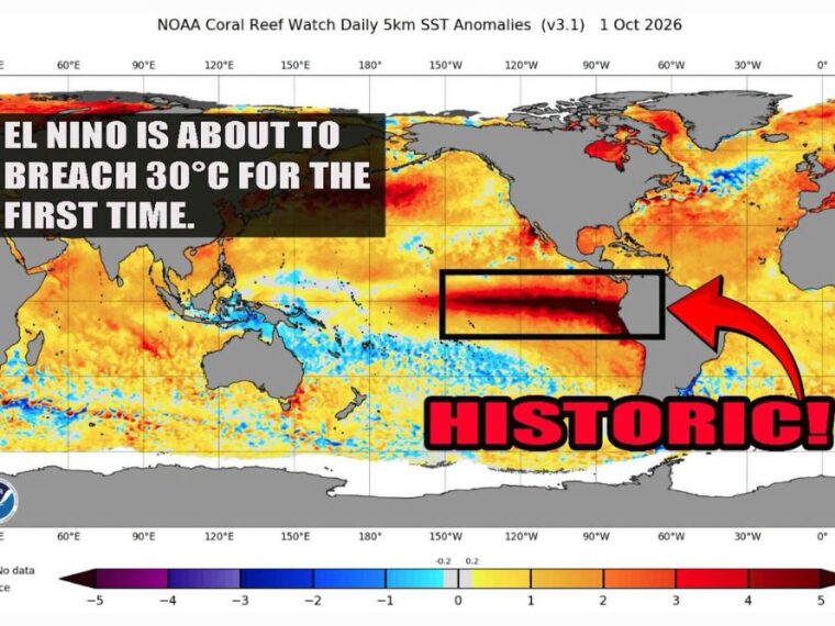
Sea surface temperature anomaly data from October 1 shows a narrow, intense band of warmth stretching along the equator from the central Pacific to the coast of South America. Within that band, waters are running roughly 4 to 5°C above normal.
The warmest anomalies are focused in the eastern Pacific near South America. Broader areas of above-normal ocean temperatures also appear across much of the North Pacific and North Atlantic.
El Nino Typically Peaks During October and November
El Nino events usually strengthen the most during October and November before peaking later in the season. That timing suggests the current event may continue gaining strength over the coming weeks.
If that pattern holds, ocean temperatures in the Nino 3.4 region could climb even higher. Any further warming would push the event deeper into record-breaking territory.
Winter Impacts Harder to Predict in Uncharted Territory
Forecasters have a general idea of what an average El Nino does to winter weather across the United States. Typical patterns include a more active storm track across the southern states and milder conditions across parts of the northern tier.
However, an event of this strength has never been observed before, making its exact effects much harder to forecast. Historical patterns may not fully apply when conditions move this far beyond past records.
Coming Months Will Reveal How the Record Event Unfolds
Weather watchers will be closely tracking how this historic El Nino develops over the coming months. Changes in ocean temperatures will help shape seasonal outlooks for rain, snow, and temperatures across the country.
Residents should keep an eye on updated winter forecasts as new data becomes available. The record-setting nature of this event means seasonal predictions could shift as the season progresses.
Stay with bananatreenews.today for the latest weather updates and local forecast coverage.