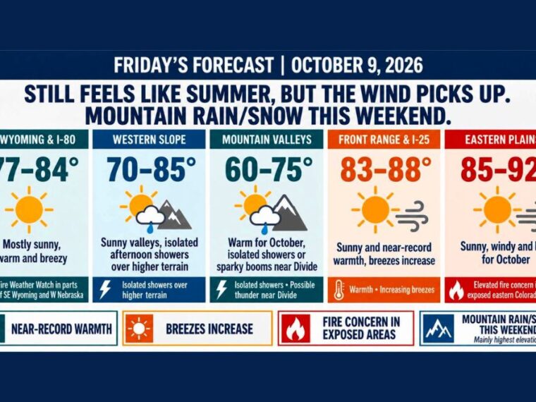
DENVER, CO — Summer-like warmth continues across Colorado on Friday, with Denver and the Interstate 25 corridor climbing into the mid to upper 80s. Some locations could approach record highs for early October. Winds will also increase, raising fire weather concerns across southeast Wyoming, western Nebraska, and the eastern plains. A pattern change arrives this weekend, bringing rain and high-elevation snow to the Western Slope and mountains.
Front Range and Eastern Plains Run Near Record Warmth
Denver and the Front Range will see highs from 83 to 88 degrees under sunny skies, with breezes increasing during the afternoon. A few spots along the I-25 corridor could flirt with record warmth.
The eastern plains will be even hotter, with highs from 85 to 92 degrees. Sunny, windy, and hot conditions are expected across eastern Colorado for much of the day.
Fire Weather Watch for Southeast Wyoming and Western Nebraska
A Fire Weather Watch is in effect for parts of southeast Wyoming and western Nebraska Friday afternoon and evening. Southeast Wyoming and the Interstate 80 corridor will see highs from 77 to 84 degrees with breezy conditions.
Farther south, warm, dry, and breezy weather will also raise fire concerns in exposed areas of eastern Colorado, even without a watch. Residents should avoid activities that could spark a fire.
Mountains See Isolated Afternoon Showers and Storms
Mountain valleys will see highs from 60 to 75 degrees, with isolated showers and a few thunderstorms possible near the Continental Divide. The Western Slope will range from 70 to 85 degrees, with sunny valleys and isolated showers over higher terrain.
Most of the I-25 corridor will stay dry, though a stray shower or storm could drift off the foothills. Anyone outdoors Friday afternoon or evening should keep an eye on the sky.
Weekend Moisture Brings Rain and Snow to the Mountains
The first better round of moisture will favor the Western Slope and mountains starting Saturday and continuing into Sunday and Monday. Some mountain communities will see rain, while snow will fall mainly on the highest peaks.
East of the Divide, including Denver and the northern Front Range, the first wave looks much drier. Summer-like warmth may hold on through Sunday along the Front Range.
Cooler and Wetter Pattern Possible Later Next Week
A cooler and wetter pattern could develop across Colorado later next week. Timing and placement of that change still need to be worked out.
For now, warm weather remains the main story across the Front Range. Residents should keep checking forecasts as signs of a fall cooldown become clearer.
Stay with bananatreenews.today for the latest weather updates and local forecast coverage.