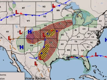
AUSTIN, TX — A stormy stretch is set to move across much of Texas, and forecasters say the biggest hazards will vary by region. Some places are facing a greater threat of flash flooding from repeated heavy rain, while others could see damaging wind, large hail and even a tornado.
The National Weather Service offices in Austin, Corpus Christi, Houston-Galveston and Dallas-Fort Worth all say the unsettled weather will unfold from Thursday into Friday, with some rain chances lingering into the weekend. In several areas, the timing of the strongest storms depends on where a front stalls or how a low-pressure system develops.
Rainfall totals could be significant in the hardest-hit corridors, with isolated amounts reaching much higher than the regional averages.
Central Texas faces flood watch and isolated eight-inch totals
Most of South Central Texas is under a Flood Watch through 7 p.m. Friday, and forecasters in Austin and San Antonio say the region could pick up widespread rainfall totals of 1 to 4 inches. Some locations may see isolated totals of up to 8 inches, especially where storms keep training over the same area.
The National Weather Service office in Austin-San Antonio says the heavier rain could quickly lead to flash flooding. It also warned that some storms may become severe, bringing damaging wind gusts and large hail, with a tornado also possible.
Rain chances do not end after Friday. Forecasters expect a continued chance of showers through the weekend, with a few lingering into Monday before drier weather returns early next week.
The Austin office said the front should move away by Tuesday, allowing upper-level ridging to return over Texas and bring back dry weather.
South Texas and the coast watch where the front stalls
Heavy rainfall is expected in South Texas on Thursday, and the National Weather Service in Corpus Christi says the flash-flood risk remains elevated through Friday evening. The office has also flagged a marginal risk that some storms could become severe.
Corpus Christi forecasters say wind damage is the main severe-weather concern. That means even outside the heaviest rain bands, some storms could produce damaging bursts of wind strong enough to cause problems for trees, power lines and travel.
A cold front is forecast to move into the Rio Grande Plains and Brush Country on Friday. It may then stall near the coast Friday night into Saturday, and that is where the heaviest rain and greatest flash-flood risk would focus.
Temperatures are less certain Thursday, but cooler weather is expected Friday and could hold into early next week as the front settles in.
Houston area storms could shift east into the Brazos Valley
Thunderstorms are expected to peak Thursday in the Houston area, according to the National Weather Service in Houston-Galveston. Forecasters are watching a possible low-pressure system that could develop and drift south, changing where the heaviest rain falls.
If that system forms and pulls the storm track east, the Brazos Valley could absorb more of the rainfall threat. The Houston office says that setup would increase flash-flood concerns there, especially with deep tropical moisture already in place.
Forecasters said rainfall rates could easily exceed 3 to 4 inches per hour during the heaviest downpours. That kind of intensity can overwhelm roads and drainage systems quickly, especially if storms repeat over the same locations.
For now, the key issue is the uncertainty in storm placement. A small shift in the system could change which communities take on the highest water risk.
North Texas watches for flash flooding west of I-35
Much of North Texas is under a Flood Watch through Friday morning, according to the National Weather Service in Dallas-Fort Worth. Forecasters say flash flooding is the main threat, although isolated severe wind gusts and a spin-up tornado are also possible with embedded convection.
The greatest rainfall totals Thursday morning are expected west of I-35, where training thunderstorms could produce localized amounts of 4 to 5 inches. That scenario would create the highest flood threat in the region if storms repeatedly move over the same corridor.
Dallas-Fort Worth forecasters also expect another round of scattered showers and storms Thursday afternoon and evening. Coverage could reach 50% to 60% near the surface boundary they are tracking.
Because of that boundary, rain chances may remain elevated even after the first wave passes, keeping travel and drainage concerns in place through the day.
Weekend rain chances linger while the front pushes east
Across Texas, the overall setup favors a drawn-out stretch of unsettled weather instead of one quick event. That means the state could deal with multiple rounds of storms, with the exact impacts shifting depending on where the front slows or stalls.
Central Texas may keep seeing showers into Monday, while South Texas and the coast could feel the strongest flood risk near the stalled front Friday night and Saturday. Houston-area storms may peak Thursday, but the next pattern change could move the rain axis east or south.
By early next week, forecasters in Austin expect the front to exit and drier weather to return. Until then, heavy rain, rapid runoff and isolated severe storms remain the main concerns for several regions.
Residents across the state are being told to pay close attention to local flood watches and weather updates as the system evolves.
Why forecasters keep focusing on rainfall totals and storm speed
The biggest concern in this pattern is not just the amount of moisture in place, but how slowly storms may move. When rainfall lines up over the same neighborhoods, totals can climb fast and flash flooding can develop before water has time to drain away.
That is why several National Weather Service offices are emphasizing localized totals instead of just broad regional averages. Central Texas could see 1 to 4 inches across wide areas, South Texas could get heavy rain near the front, and North Texas could face 4 to 5 inches west of I-35 if storms train.
At the same time, the severe-weather threat cannot be ignored. Large hail, damaging winds and a tornado remain possible in some areas, even where flooding is the dominant hazard.
The forecast points to a storm system that will affect different parts of Texas in different ways, but nearly every region will have something to watch closely through the end of the week.