TALLAHASSEE, FL — A stalled front is expected to deliver solid rainfall totals across much of Florida next week, regardless of whether anything tropical forms in the Gulf. The heaviest totals are likely to end up across North Florida, including the Panhandle and the Big Bend. The seven-day rainfall outlook runs from Saturday, October 3 through Saturday, October 10. Tropical development in the Gulf remains possible, but the rain threat does not depend on it.
Seven-Day Outlook Shows the Heaviest Rain Across North Florida
The seven-day rainfall forecast shows a broad zone of 3 to 5 inches across North Florida and the Panhandle. Tallahassee, Jacksonville, and Gainesville all fall within the heavier shading on the outlook.
Some of the highest totals, near 4 to 5 inches or more, are focused over the northeastern Gulf just offshore. Coastal communities closest to that zone could see rain totals add up quickly as the front stalls.
Heavy Rain Zone Extends Across the Gulf Coast and Southeast
The heavy rain band stretches well beyond Florida, covering the Louisiana coast, the Mississippi and Alabama coastline, and south Georgia. Heavy totals also extend up the Southeast coast toward South Carolina and into the nearby Atlantic.
Along the south Texas coast, another pocket of heavier rain appears on the outlook. Farther inland across the central United States, rainfall totals drop off sharply, with much of the Plains and Midwest staying mostly dry.
Central and South Florida Also Pick Up Meaningful Rain
Central Florida, including areas around Orlando and Tampa, is also in line for solid rain totals through the week. Amounts generally range from 2 to 4 inches across much of the central peninsula.
South Florida shows somewhat lower totals compared with the northern half of the state. Even so, several rounds of rain are possible as moisture lingers along the stalled boundary.
Gulf Development Chances Focus on the Southwestern Gulf
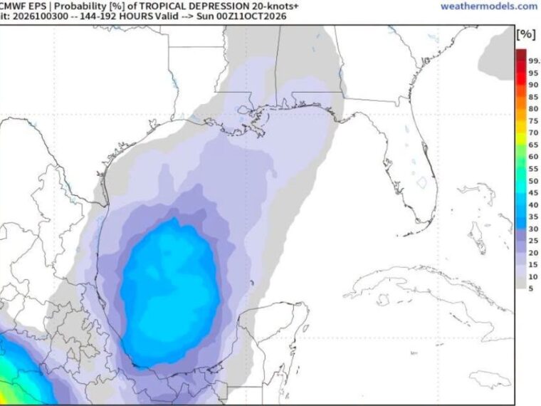
Development probability guidance shows the highest chances for a tropical system in the southwestern Gulf near the Bay of Campeche. Probabilities in that area reach around 40 to 50 percent on the ensemble outlook.
Lower probabilities extend north across the Gulf toward the Louisiana coast and the Florida Panhandle. Ensemble tracks are widely scattered, with some lines heading toward Texas and Louisiana and others crossing Florida, showing a high level of uncertainty.
Florida Residents Should Prepare for a Wet Week Ahead
Residents across Florida, especially in the northern part of the state, should prepare for a wet stretch of weather next week. Repeated rounds of rain could lead to ponding on roads and localized flooding in low-lying areas.
Anyone with outdoor plans should keep an eye on daily forecast updates as the week unfolds. The tropical outlook may change, but the stalled front alone is expected to keep rain chances high across much of the state.
Stay with bananatreenews.today for the latest weather updates and local forecast coverage.